
UN General Assembly Adopts Resolution to Replace Mercator Projection
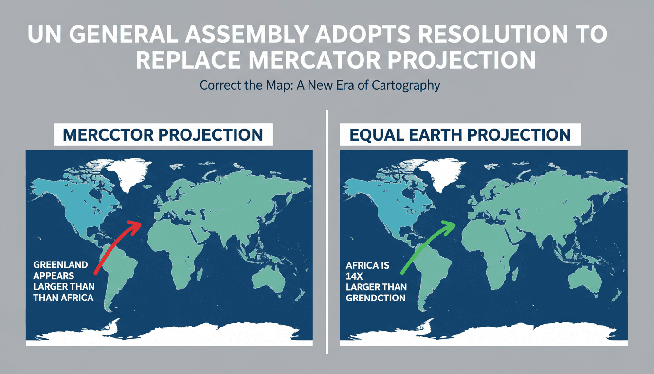
Here's what it means for you.
As global mapping standards shift, your understanding of geography and its implications on global perspectives may evolve.
Why it matters
This resolution addresses long-standing geographic misconceptions that can influence education, policy, and international relations.
What happened (in 30 seconds)
- On September 5, 2026, the UN General Assembly adopted the 'Correct the Map' resolution, urging a shift from the Mercator projection.
- The resolution promotes the Equal Earth map, which accurately represents landmass sizes, particularly highlighting Africa's true scale.
- The United States was the only opposing vote, with six abstentions, indicating geopolitical tensions around cartographic standards.
The context you actually need
- The Mercator projection, created in 1569, distorts land areas, making regions like Greenland appear larger than they are compared to Africa.
- Geopolitical critiques have highlighted how these distortions minimize the significance of equatorial regions, affecting perceptions and policies.
- The Equal Earth projection, developed in 2018, aims to provide a more accurate representation while maintaining some navigational utility.
What's really happening
The adoption of the 'Correct the Map' resolution by the UN General Assembly marks a significant shift in how global cartographic standards are perceived and implemented. The Mercator projection, which has dominated map-making for centuries, was originally designed for maritime navigation. However, its inherent distortions have led to a skewed understanding of the world, particularly regarding the relative sizes of continents. For instance, Africa is approximately 14 times larger than Greenland, yet the Mercator projection presents them as comparable in size. This misrepresentation has far-reaching implications, influencing everything from educational materials to international policy discussions.
The resolution builds on the earlier endorsement of the Equal Earth projection by the African Union in February 2026, which reflects a growing recognition of the need for more accurate representations of geography. The Equal Earth map prioritizes equal-area representation, allowing for a more truthful depiction of landmass sizes while still retaining some navigational features. This shift is not merely academic; it has practical implications for how countries and organizations approach issues like climate change, resource allocation, and geopolitical strategy.
The non-binding nature of the resolution means that its implementation will be voluntary, leading to a patchwork of adoption across different institutions. Schools, governments, and organizations will need to evaluate their current mapping practices and consider transitioning away from the Mercator projection. This could lead to significant changes in educational curricula, public policy, and even international relations as perceptions of geography evolve.
The United States' opposition to the resolution, along with six abstentions, highlights the geopolitical tensions that can arise from such shifts. The U.S. has historically favored the Mercator projection, which aligns with its own geopolitical interests. As countries and organizations begin to adopt alternative projections, the implications for global diplomacy and cooperation could be profound.
In summary, the 'Correct the Map' resolution is not just about maps; it's about how we understand our world and the power dynamics that shape our perceptions. As institutions begin to adopt more accurate representations, the potential for a more equitable understanding of global geography emerges.
Who feels it first (and how)
- Educators: Curriculum changes may require new teaching materials and methods.
- Geographers and cartographers: Professionals will need to adapt to new standards and projections.
- Policymakers: Decisions based on geographic data may shift as perceptions of landmass significance change.
- Students: Learners will gain a more accurate understanding of global geography, impacting their worldview.
- International organizations: Groups focused on global issues may need to reassess their strategies based on new geographic insights.
What to watch next
- Adoption rates of the Equal Earth projection: Monitoring how quickly schools and organizations transition will indicate the resolution's impact.
- Geopolitical responses: Observing how countries react to the shift in mapping standards, particularly the U.S., will reveal underlying tensions.
- Changes in educational materials: Tracking updates in textbooks and curricula will show how geography education evolves in response to the resolution.
The Mercator projection distorts landmass sizes, particularly affecting perceptions of Africa.
Educational institutions will begin to adopt the Equal Earth projection in curricula.
The long-term geopolitical implications of this resolution on international relations remain to be seen.
Frequently Asked Questions
- Why it matters?
- This resolution addresses long-standing geographic misconceptions that can influence education, policy, and international relations.
- What happened (in 30 seconds)?
- On September 5, 2026, the UN General Assembly adopted the 'Correct the Map' resolution, urging a shift from the Mercator projection. The resolution promotes the Equal Earth map, which accurately represents landmass sizes, particularly highlighting Africa's true scale. The United States was the only opposing vote, with six abstentions, indicating geopolitical tensions around cartographic standards.
- What's really happening?
- The adoption of the 'Correct the Map' resolution by the UN General Assembly marks a significant shift in how global cartographic standards are perceived and implemented. The Mercator projection, which has dominated map-making for centuries, was originally designed for maritime navigation. However, its inherent distortions have led to a skewed understanding of the world, particularly regarding the relative sizes of continents. For instance, Africa is approximately 14 times larger than Greenland,
- Who feels it first (and how)?
- Educators: Curriculum changes may require new teaching materials and methods. Geographers and cartographers: Professionals will need to adapt to new standards and projections. Policymakers: Decisions based on geographic data may shift as perceptions of landmass significance change. Students: Learners will gain a more accurate understanding of global geography, impacting their worldview. International organizations: Groups focused on global issues may need to reassess their strategies bas
- What to watch next?
- Adoption rates of the Equal Earth projection: Monitoring how quickly schools and organizations transition will indicate the resolution's impact. Geopolitical responses: Observing how countries react to the shift in mapping standards, particularly the U.S., will reveal underlying tensions. Changes in educational materials: Tracking updates in textbooks and curricula will show how geography education evolves in response to the resolution.
International coverage of politics, culture, and current affairs.
"BBC News is widely regarded as a reputable international news organization, known for its impartial tone and public service mandate."
— A47 Editor
What different world maps get right - and what they get wrong
The United Nations has adopted a new world map that accurately reflects Africa's true size, moving away from the historically criticized Mercator projection. This decision was made during a session with participation from over 160 countries, emphasiz...
International news, politics, and culture.
"Sky News is a UK-based 24-hour channel known for fast-breaking news and political coverage."
— A47 Editor
New world map that shows Africa's true size backed by UN
Over 160 countries at the United Nations have voted to adopt a new world map that accurately represents Africa's true size, moving away from the traditional Mercator projection that has been in use for nearly 500 years. This decision is a significant...
International coverage from The Guardian's global desks.
"The Guardian is known for its progressive editorial stance and in-depth analysis."
— A47 Editor
UN votes to adopt new world map that shows Africa’s true scale
The United Nations has officially adopted a resolution to phase out the traditional Mercator map in favor of a new world map that accurately represents Africa's true size, following a vote that included over 160 countries. This decision marks a signi...