
UN General Assembly Adopts Equal Earth Projection to Accurately Represent Africa's Size
Here's what it means for you.
As a global citizen, understanding accurate geographical representations can reshape your perception of international relations and economic dynamics.
Why it matters
This resolution addresses long-standing biases in global mapping that affect educational, political, and economic narratives.
What happened (in 30 seconds)
- On September 4, 2026, the UN General Assembly adopted the 'Correct the Map' resolution, endorsing the Equal Earth projection.
- The vote was 164 to 1, with the United States opposing and six countries abstaining.
- The resolution is non-binding, encouraging voluntary adoption of the Equal Earth projection over the Mercator projection.
The context you actually need
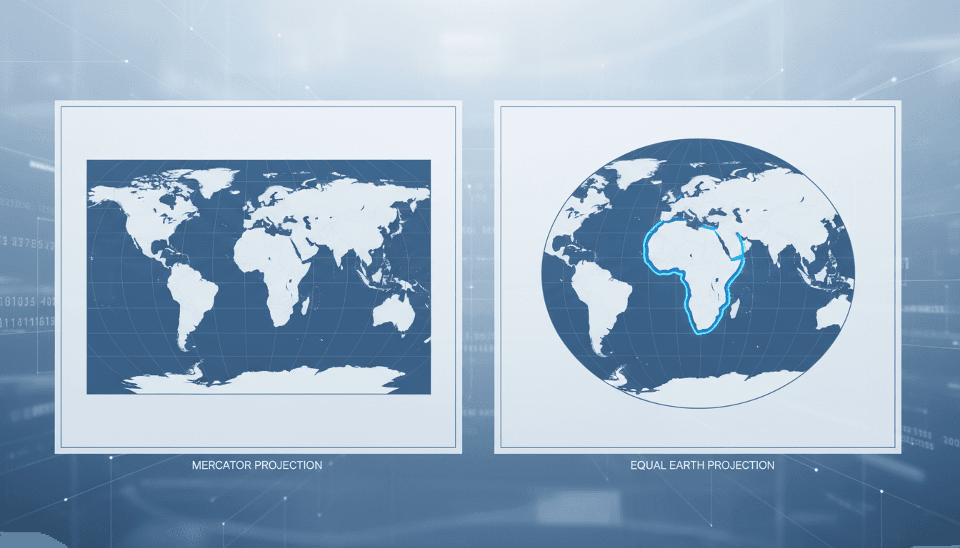
- The Mercator projection, created in 1569, distorts landmass sizes, making regions near the poles appear larger than they are, while minimizing equatorial regions like Africa.
- The Equal Earth projection, introduced in 2018, offers a more accurate representation of land areas, promoting a better understanding of global geography.
- The African Union's support for this resolution reflects a broader movement to correct historical biases in how continents are represented in educational and media contexts.
What's really happening
The endorsement of the Equal Earth projection by the United Nations General Assembly marks a significant shift in how global geography is perceived and taught. Historically, the Mercator projection has been the dominant map used in education and navigation, despite its well-documented distortions. This projection enlarges landmasses near the poles, such as Greenland, while drastically shrinking those near the equator, particularly Africa, which is actually 14 times larger than Greenland when measured accurately.
The resolution, introduced by Togo on behalf of the African Group, highlights the importance of accurate geographical representation in shaping perceptions of global power dynamics. Togo's Foreign Minister Robert Dussey emphasized that maps are not just tools for navigation; they influence how people view different regions and their significance on the world stage. The African Union's backing of this initiative underscores a collective desire to rectify historical misrepresentations that have contributed to a skewed understanding of Africa's geopolitical weight.
The U.S. was the only country to oppose the resolution, citing concerns over potential ideological agendas. This opposition reflects a broader tension between traditional mapping practices and emerging calls for more equitable representations. While the resolution is non-binding, its adoption could lead to gradual changes in educational curricula, media representations, and digital platforms, particularly in countries with significant global influence.
In practical terms, the resolution encourages governments, educational institutions, and media outlets to adopt the Equal Earth projection voluntarily. This could lead to a cultural shift in how geography is taught and understood, fostering a more accurate perception of Africa's size and significance. As countries like France announce plans to abandon the Mercator projection in official representations, the momentum for change is building.
However, the non-binding nature of the resolution means that immediate market shifts are unlikely. The impact will be felt more in educational and media contexts than in economic terms, at least in the short term. Campaigners for accurate mapping will continue to advocate for institutional adoption, pushing for a broader acceptance of the Equal Earth projection in various sectors.
Who feels it first (and how)
- Educators: Curriculum changes may lead to more accurate geography education.
- Media professionals: News graphics and representations may shift towards equal-area maps.
- Students: Learners will gain a more accurate understanding of global geography.
- Policymakers: Increased awareness of Africa's size may influence international relations and development policies.
- Digital platforms: Tech companies may update mapping services to reflect the Equal Earth projection.
What to watch next
- Adoption rates of the Equal Earth projection: Monitor how quickly educational institutions and media outlets begin to implement this new mapping standard.
- Responses from other nations: Watch for how countries beyond the U.S. react to the resolution and whether they adopt similar measures.
- Changes in public perception: Assess shifts in how people view Africa's geopolitical significance as more accurate maps become prevalent.
The UN General Assembly has endorsed the Equal Earth projection.
Educational institutions will gradually adopt the Equal Earth projection in curricula.
The long-term economic impacts of this resolution on global trade and relations remain uncertain.
Frequently Asked Questions
- Why it matters?
- This resolution addresses long-standing biases in global mapping that affect educational, political, and economic narratives.
- What happened (in 30 seconds)?
- On September 4, 2026, the UN General Assembly adopted the 'Correct the Map' resolution, endorsing the Equal Earth projection. The vote was 164 to 1, with the United States opposing and six countries abstaining. The resolution is non-binding, encouraging voluntary adoption of the Equal Earth projection over the Mercator projection.
- What's really happening?
- The endorsement of the Equal Earth projection by the United Nations General Assembly marks a significant shift in how global geography is perceived and taught. Historically, the Mercator projection has been the dominant map used in education and navigation, despite its well-documented distortions. This projection enlarges landmasses near the poles, such as Greenland, while drastically shrinking those near the equator, particularly Africa, which is actually 14 times larger than Greenland when mea
- Who feels it first (and how)?
- Educators: Curriculum changes may lead to more accurate geography education. Media professionals: News graphics and representations may shift towards equal-area maps. Students: Learners will gain a more accurate understanding of global geography. Policymakers: Increased awareness of Africa's size may influence international relations and development policies. Digital platforms: Tech companies may update mapping services to reflect the Equal Earth projection.
- What to watch next?
- Adoption rates of the Equal Earth projection: Monitor how quickly educational institutions and media outlets begin to implement this new mapping standard. Responses from other nations: Watch for how countries beyond the U.S. react to the resolution and whether they adopt similar measures. Changes in public perception: Assess shifts in how people view Africa's geopolitical significance as more accurate maps become prevalent.
International stories from NPR’s global desk.
"NPR is an American public media organization known for thoughtful reporting and a slightly left-leaning editorial tone."
— A47 Editor
The U.N. backs a new world map showing Africa in its true relative size
The U.N. has endorsed a new world map that accurately represents Africa's size, countering long-standing misconceptions perpetuated by previous cartographic representations. This decision highlights the importance of geographical accuracy in global d...
International news coverage curated for readers in the UAE and Gulf region.
"Emirates 24|7 world coverage presents global developments through a UAE-facing and Gulf-relevant editorial lens."
— A47 Editor
UN adopts resolution to correct world map representation
The United Nations General Assembly has adopted a resolution aimed at achieving more accurate representation of continents on world maps, particularly focusing on correcting the historical distortions that affect Africa's size in cartographic represe...
International news, politics, and culture.
"Sky News is a UK-based 24-hour channel known for fast-breaking news and political coverage."
— A47 Editor
New world map that shows Africa's true size backed by UN
Over 160 countries at the United Nations have voted to adopt a new world map that accurately represents Africa's true size, moving away from the traditional Mercator projection that has been in use for nearly 500 years. This decision is a significant...
Global news coverage with extensive reporting on Middle Eastern conflicts and geopolitics.
"Al Jazeera is a Qatar-based broadcaster known for wide regional coverage and alternative perspectives."
— A47 Editor
UN votes to adopt new world map that reflects Africa’s true size
The United Nations has voted to adopt a new world map that accurately reflects Africa's true size, moving away from the historically criticized Mercator projection. This decision was made during a session where over 160 countries participated, emphas...
Comprehensive coverage of Middle Eastern and global issues.
"Al Jazeera is a prominent voice from the Global South, especially the Middle East, with an emphasis on underreported stories."
— A47 Editor
UN votes to adopt new world map that reflects Africa’s true size
The United Nations has voted to adopt a new world map that accurately reflects Africa's true size, moving away from the historically criticized Mercator projection. This decision was made during a session where over 160 countries participated, emphas...
24/7 international news from a French perspective in multiple languages.
"France 24 is viewed as a globally focused outlet with balanced coverage and a European perspective."
— A47 Editor
UN ditches Mercator map to adopt more accurate one reflecting Africa's true size
The UN General Assembly has voted to replace the 16th-century Mercator map with a more accurate representation of the world's continents, particularly highlighting Africa's true size. This resolution, led by several African nations and co-sponsored b...
UAE-based English-language newspaper covering regional politics, economics, and global affairs.
"The National reflects Emirati policy perspectives while maintaining international editorial standards."
— A47 Editor
US opposes UN adoption of map showing Africa’s true size
The United States has expressed opposition to the United Nations' recent decision to adopt a new world map that accurately represents Africa's true size, moving away from the historically criticized Mercator projection. This decision was made during ...
International coverage from The Guardian's global desks.
"The Guardian is known for its progressive editorial stance and in-depth analysis."
— A47 Editor
UN votes to adopt new world map that shows Africa’s true scale
The United Nations has officially adopted a resolution to phase out the traditional Mercator map in favor of a new world map that accurately represents Africa's true size, following a vote that included over 160 countries. This decision marks a signi...
English-language news from Qatar covering domestic and regional affairs.
"Gulf Times reflects Qatari perspectives on regional developments."
— A47 Editor
UN approves resolution in support of map that shows Africa's true size
The United Nations recently approved a resolution advocating for a new map that accurately represents the true size of African countries, moving away from the outdated Mercator projection. This resolution was primarily sponsored by African nations, h...