
Three Pacific Hurricanes Highlight Strong El Niño Effects
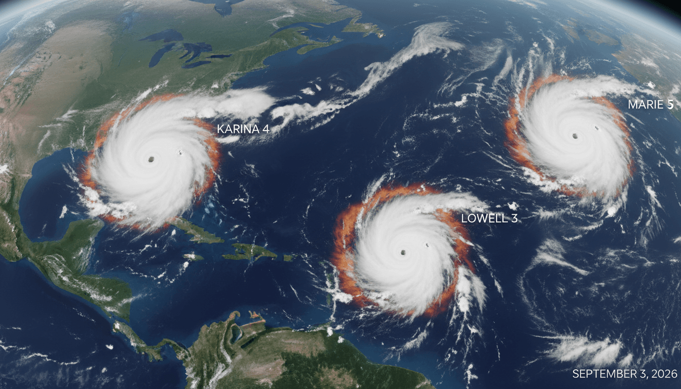
Here's what it means for you.
The simultaneous occurrence of three hurricanes in the Pacific highlights the growing impact of climate patterns on global weather systems.
Why it matters
This event underscores the increasing intensity of tropical cyclones linked to climate change, affecting global weather patterns and economic stability.
What happened (in 30 seconds)
- Three hurricanes—Karina, Lowell, and Marie—were simultaneously active in the Pacific on September 3, 2026.
- El Niño conditions contributed to unusually warm sea surface temperatures, enhancing cyclone activity.
- This rare occurrence is the first of its kind since 2015, indicating a trend of intensified Pacific hurricane seasons.
The context you actually need
- El Niño events typically warm sea surface temperatures in the eastern Pacific, creating favorable conditions for hurricane formation.
- The 2026 episode is projected to be among the most intense on record, following patterns seen in previous strong El Niño years.
- Pacific hurricane activity tends to increase during El Niño years while suppressing Atlantic hurricane formation, altering regional weather dynamics.
What's really happening
In early September 2026, the Pacific Ocean witnessed a rare meteorological phenomenon: three hurricanes—Karina, Lowell, and Marie—active simultaneously. This event is significant not just for its rarity but also for what it reveals about the ongoing effects of climate change, particularly through the lens of El Niño.
El Niño is characterized by warmer-than-average sea surface temperatures in the eastern tropical Pacific, which can lead to reduced vertical wind shear. This reduction creates an environment conducive to the formation and intensification of tropical cyclones. The 2026 El Niño episode is projected to rank among the most intense on record, with forecasts indicating that it could continue to influence weather patterns through early 2027.
The simultaneous activity of these hurricanes is a clear indicator of the enhanced cyclone activity that can occur during strong El Niño years. Hurricanes Karina and Lowell reached Category 4 and Category 5 statuses, respectively, while Marie remained at Category 1. This level of activity is not just a statistical anomaly; it reflects a broader trend of increasing cyclone intensity and frequency linked to climate change.
The implications of this event extend beyond the immediate impacts on coastal regions. For instance, the storms generated high waves and rip currents that could affect areas as far away as Hawaii and the U.S. West Coast. Moreover, the enhanced activity in the Pacific often correlates with suppressed hurricane formation in the Atlantic, which can have significant implications for regions that typically experience hurricane threats.
Meteorological agencies, including the National Hurricane Center and NOAA, are closely monitoring these developments. Their ongoing assessments will be crucial for understanding how this El Niño episode will evolve and what it means for global weather patterns. The interconnectedness of climate systems means that changes in one region can have ripple effects worldwide, influencing everything from agricultural productivity to disaster preparedness.
Who feels it first (and how)
- Coastal residents in the Pacific region, particularly in Hawaii and the U.S. West Coast, face immediate threats from high waves and rip currents.
- Meteorological agencies are tasked with monitoring and forecasting storm paths, impacting their operational strategies.
- Insurance and disaster recovery sectors may see increased claims and demand for services due to heightened storm activity.
What to watch next
- El Niño intensity: Continued monitoring of sea surface temperatures will indicate whether the current El Niño will strengthen or weaken, affecting future storm activity.
- Hurricane forecasts: Updates from meteorological agencies will provide insights into potential future storms and their projected paths.
- Global climate discussions: Increased cyclone activity may drive more robust international dialogues on climate change and disaster preparedness.
The occurrence of three simultaneous hurricanes is the first since 2015, driven by strong El Niño conditions.
Enhanced cyclone activity will continue as long as El Niño conditions persist, impacting global weather patterns.
The long-term implications of this El Niño on future hurricane seasons and global climate policy remain to be fully understood.
Frequently Asked Questions
- Why it matters?
- This event underscores the increasing intensity of tropical cyclones linked to climate change, affecting global weather patterns and economic stability.
- What happened (in 30 seconds)?
- Three hurricanes—Karina, Lowell, and Marie—were simultaneously active in the Pacific on September 3, 2026. El Niño conditions contributed to unusually warm sea surface temperatures, enhancing cyclone activity. This rare occurrence is the first of its kind since 2015, indicating a trend of intensified Pacific hurricane seasons.
- What's really happening?
- In early September 2026, the Pacific Ocean witnessed a rare meteorological phenomenon: three hurricanes—Karina, Lowell, and Marie—active simultaneously. This event is significant not just for its rarity but also for what it reveals about the ongoing effects of climate change, particularly through the lens of El Niño. El Niño is characterized by warmer-than-average sea surface temperatures in the eastern tropical Pacific, which can lead to reduced vertical wind shear. This reduction creates an
- Who feels it first (and how)?
- Coastal residents in the Pacific region, particularly in Hawaii and the U.S. West Coast, face immediate threats from high waves and rip currents. Meteorological agencies are tasked with monitoring and forecasting storm paths, impacting their operational strategies. Insurance and disaster recovery sectors may see increased claims and demand for services due to heightened storm activity.
- What to watch next?
- El Niño intensity: Continued monitoring of sea surface temperatures will indicate whether the current El Niño will strengthen or weaken, affecting future storm activity. Hurricane forecasts: Updates from meteorological agencies will provide insights into potential future storms and their projected paths. Global climate discussions: Increased cyclone activity may drive more robust international dialogues on climate change and disaster preparedness.
International news, politics, and culture.
"Sky News is a UK-based 24-hour channel known for fast-breaking news and political coverage."
— A47 Editor
Three hurricanes in Pacific show the power of El Nino
Three hurricanes, Lowell, Karina, and Marie, are currently active in the Pacific, showcasing a level of heightened activity associated with the El Nino phenomenon, as reported by NOAA. This situation reflects the climatic conditions that can lead to ...
Top international stories selected by The Guardian editors.
"The Guardian is known for its progressive editorial stance and in-depth analysis."
— A47 Editor
Weather tracker: Hurricanes in the Pacific, but none yet this season in the Atlantic
Currently, the Pacific Ocean is experiencing significant hurricane activity with two category 4 hurricanes, Lowell and Karina, and one category 1 hurricane, Marie, while the Atlantic has yet to see any hurricanes this season, marking a rare occurrenc...
News across North, Central, and South America including politics and economics.
"France 24 is viewed as a globally focused outlet with balanced coverage and a European perspective."
— A47 Editor
Rare train of cyclones fuelled by historic El Nino make their way across Pacific
Several storms, including Hurricane Lowell and Hurricane Karina, have formed in the Pacific Ocean, driven by a historically strong El Nino phenomenon. This climate pattern is expected to persist through February, contributing to the development of th...